

Between November 20 and December 23, 1797, the North Carolina General Assembly convened for the 22nd time (total) and 4th time in the state capitol of Raleigh. Among the items approved at the session was the establishment “at or near Cox’s Mill on Deep River in the county of Randolph” a town that would be called “Coxborough.” I’m familiar with the references of area around the Cox family mills as “Cox’s Settlement,” but only recently became aware of an actual town being envisioned by the State of North Carolina. So here’s what I’ve learned…
Deep and Haw River Navigation Company
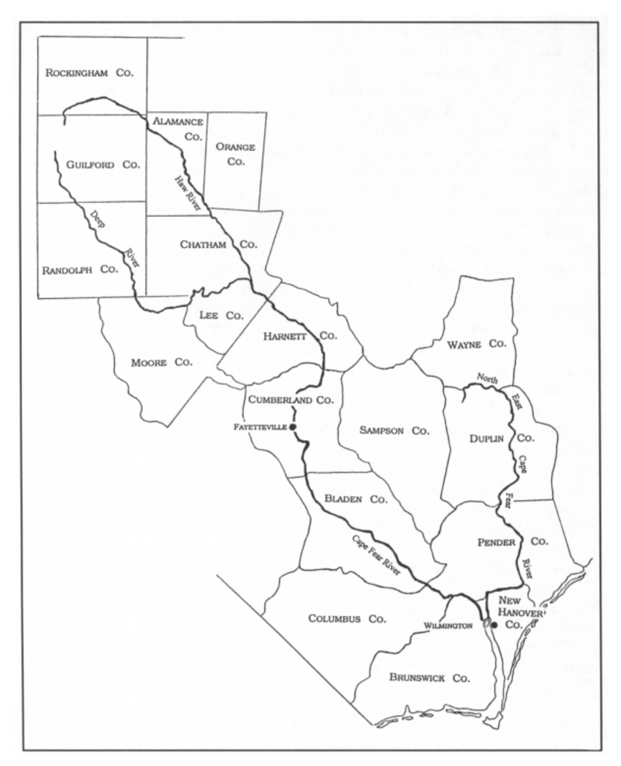
In the late 1700s, river corridors were envisioned as opportunities to improve transport of goods and raw materials to and from the coastal region. The General Assembly created the Deep and Haw River Navigation Company in 1796 to improve navigation on the Cape Fear River above Fayetteville, including the the lower parts of the Deep and Haw Rivers. Cape Fear is the only major river in North Carolina that flows directly into the Atlantic Ocean. (Rivers such as the Neuse flow into sounds.)
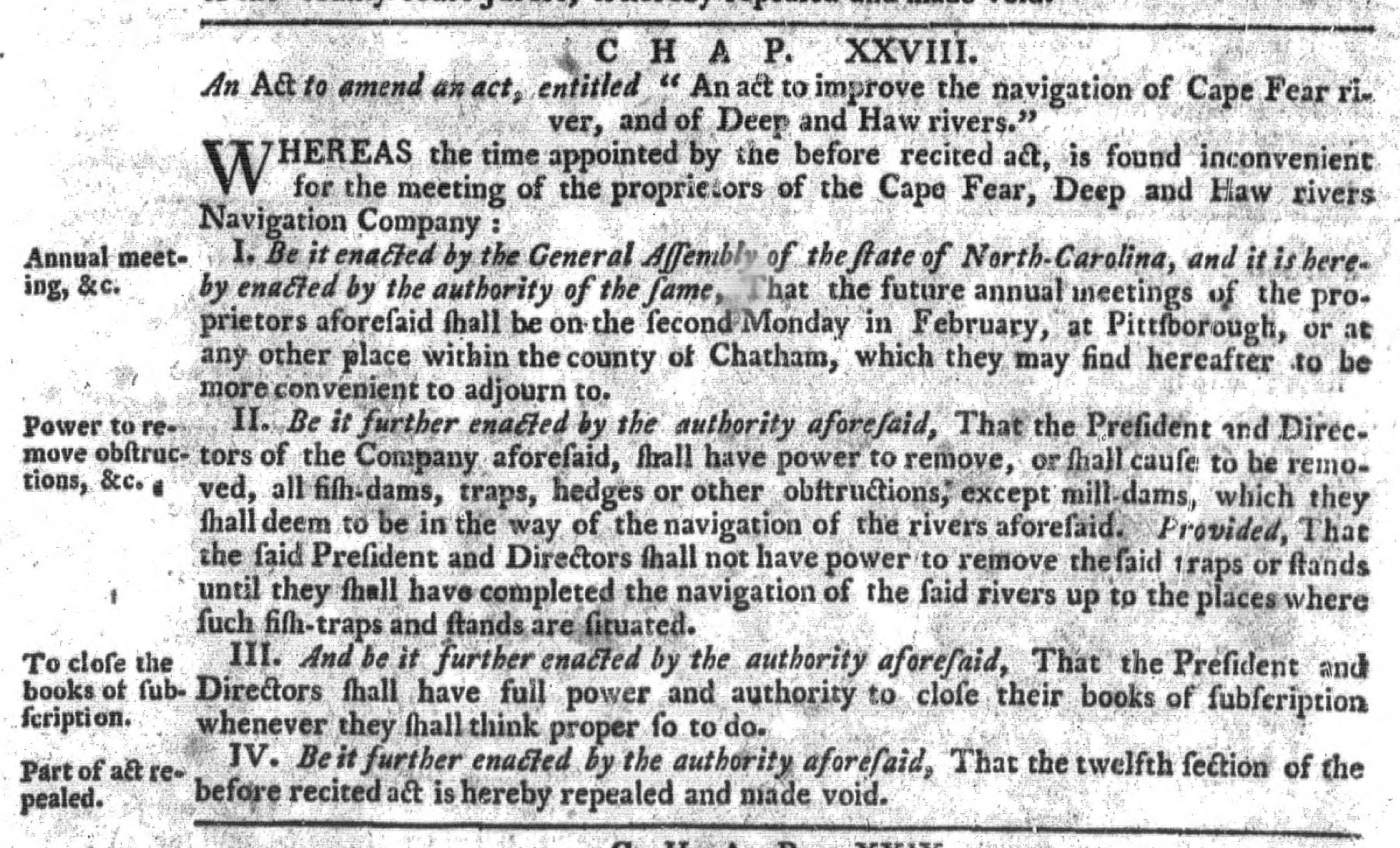
The general notion was to work on narrow, shallow, and rocky areas of the rivers, including the removal of “fish-dams, traps, hedges or other obstructions.” Funding for the company came from the issuance of $8,000 worth of stock at $5 per share. Similar companies were formed in the 1700s-1800s for other NC rivers such as the Yadkin, Tar, Neuse, Catawba, et al.
Cox’s Mill, Buffalo Ford, and Cox’s Settlement
In the mid 1700s, Quaker families of English and Irish descent were migrating to the Carolinas and settling around the tributaries of Haw and Deep Rivers, including Cane Creek, near today’s Snow Camp, and Mill Creek in southern Randolph County. The settlers successfully grew grain crops such as wheat and corn, and built gristmills to make flour. In addition to milling their own crops, mill owners processed the crops of other farmers, often receiving a portion of the finished product as payment.
Some mills packaged flour for sale to the general public, and became centers of trade and communication for the local population. Blacksmith and sawmill services might be found at the local mill, if not on site, through word of mouth as to who might provide the service.
While the full extent of services provided by the Cox mills near Deep River is uncertain, the Cox name and mill operation became identifiers of the general area. “Cox’s Mill Creek” is found in the descriptions of land grant surveys of the 1750s. Randolph County historian Mac Whatley points to other notations, such as Orange County Court minutes for Nov. 1763 ordering a “Road be laid out from Coxes Mill to Collinses Road.” Mentions of “Cox’s Mill” continue through the 1760s and 1770s as the location for Regulator committee meetings and headquarters for Tory leader David Fanning. During the American Revolution, Cox’s Mill was declared a public store and protected against destruction by either army. It is also the general location where the Continental Army camped in 1780 while awaiting the arrival of General Horatio Gates prior to the ill fated battle at Camden.
“Buffalo Ford” also commonly appears as an area identifier. This Randolph County Cultural Heritage Site is where the east-west road from Salisbury to Cross Creek (Fayetteville) and the north-south road from Hillsborough to Camden crossed Deep River. Land including the ford was secured by William Cox in a 1755 Lord Granville Grant, so it’s reasonable to assume trade and commerce occurred at the mill.

By the 1760’s, “Cox’s Settlement” emerges as a term of reference. In Cane Creek: Mother of Meetings (1995), Bobbie Teague writes, “Mill Creek Meeting was located in Cox’s Settlement in an area which later became Randolph County.” This was pulled by the author from Cane Creek Meeting records, and seems to be the earliest use of the term.
I emailed Cox family historian (and my cousin) Emily Cox Johnson, and she replied, “This was something that I had heard most of my life. I have been asked many times if I lived in the Coxsborough area and the answer was yes.” Regarding the river project, Emily adds, “This area did a lot of trading in Fayetteville and river travel would have been much easier than land travel with wagons. The story was that locks would be built up and down Deep River to make the river navigable. Deep River was deep in places, rocky in others, so boats hauling goods would not be able to travel up river very far.”
Ok, but…Coxborough?
As North Carolina was being colonized, places sometimes retained the Native American name (Chowan, Saxapahaw) or were named for nobility (Orange County, Wilmington), geographic features (Rocky River, Sapphire), or early settlers like the Coxes. A suffix was often added, such as -ville, -ton (or town), and -borough. “Borough” is a suffix common to England towns, and also implies a town chartered by a legislative body for a specific purpose. It seems “Coxborough” is a combination of these naming conventions.
Legislation
The “act to establish a town at or near Cox’s Mill, on Deep River…” authorizes the Deep and Haw River Navigation Company to build a hub of commerce with “ware-houses and other buildings for the reception of commodities.”
All of this, of course, was contingent of the company implementing improvements needed for the river to be a transport option. By 1830, the company had decided to focus on river improvements between Fayetteville and Wilmington, and any thoughts of a “Coxborough” were abandoned. However, Warren Dixon, (another Randolph County historian) sent me a list of “North Carolina Incorporated Towns Whose Charters Have Been Repealed or Which are Currently Inactive.” It appears “Coxborough” was never formally repealed.
So you’re saying there’s a chance…
Sources of note:

Nice work….very enjoyable reading…..
Rich Marshall