
A distant cousin from Washington State contacted me through Ancestry.com regarding land grants obtained by the Cox family in the 1700s. We share the same 6th great grandparents, William and Katherine Kinkey Cox. William and his sons secured thousands of acres of land grants along Deep River in today’s Randolph County, NC. My newly found cousin and I are in the process of mapping these grants as accurately as possible.
Update July, 2024: I am in doubt as to whether the 350 acres on New Hope Creek acquired in 1759 is one of “our” William’s grants. The names of the chain carriers are unique to this document and are not Quakers or family. It is also an outlier in location. There was another William Cox that lived in or near Hillsborough, so it makes more sense for this to be his grant.
Land Grants In 1700s North Carolina
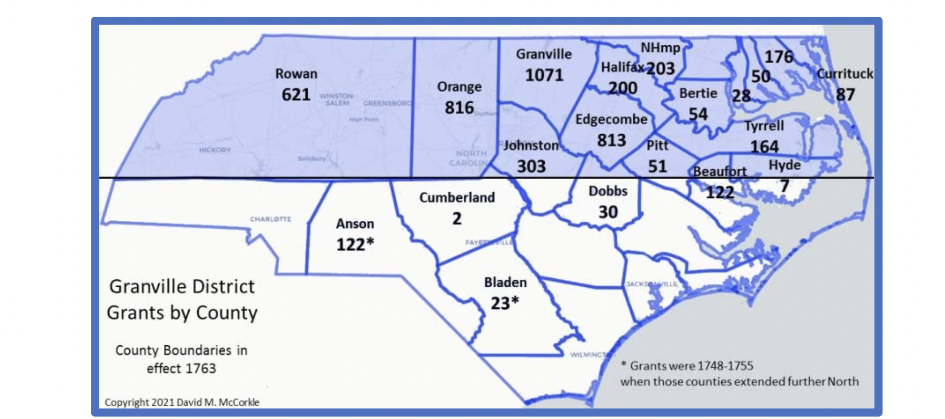
Land in today’s Georgia, North and South Carolina was given by England’s King Charles II to eight men that had aided his return to the throne in 1660. These eight “Lords Proprietors” governed the Carolinas, distributing land to settlers and collecting taxes. By 1729, the English Crown had bought back the holdings of seven of the Lords Proprietors (or their heirs), the exception being the heir of Sir George Carteret, John Lord Carteret, who kept his one-eighth share. The large tract was known as the Granville District, and grants secured in this area are called “Lord Granville Grants.” This map from noted genealogist David McCorkle shows the Granville District.
Grants secured by William, Harmon, and Thomas
By the early 1750s, William and his sons relocated to North Carolina after the death of his wife. He was accepted to the Cane Creek Friends Meeting in 1753. William’s first grants were secured in 1754 on Deep River, strategically located include portions of the creeks know today as Mill, Millstone, and Reed. Clearly there was a water driven acquisition strategy as later reflected in the operation of grist mills.
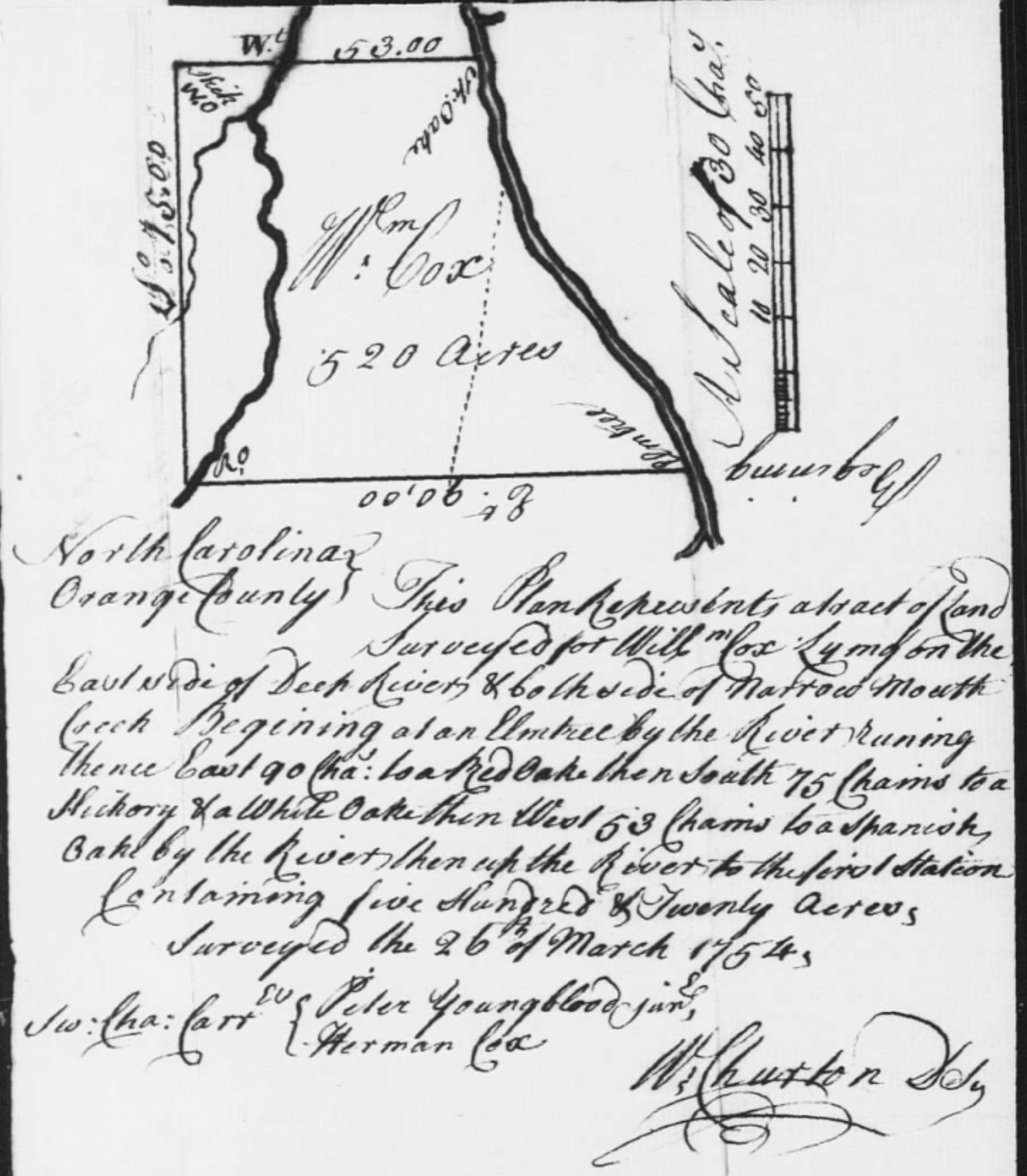
Gv42 Granville to William Cox, 11 June 1754, 520 acres on East side of Deep River, both sides of Narrowmouth Creek, SCC: Peter Youngblood Jr & Harmon Cox – surveyed on 26 March 1754 by William Churton.
Gv41 Granville to William Cox, 11 June 1754, 520 acres on West side of Deep River, SCC: Benjamin Williams & Harmon Cox – surveyed on 25 March 1754 by William Churton.

Gv40 Granville to William Cox, 11 June 1754, 400 acres on West side of Deep River, SCC: Peter Youngblood Jr & Harmon Cox – surveyed on 25 May 1754 by William Churton.

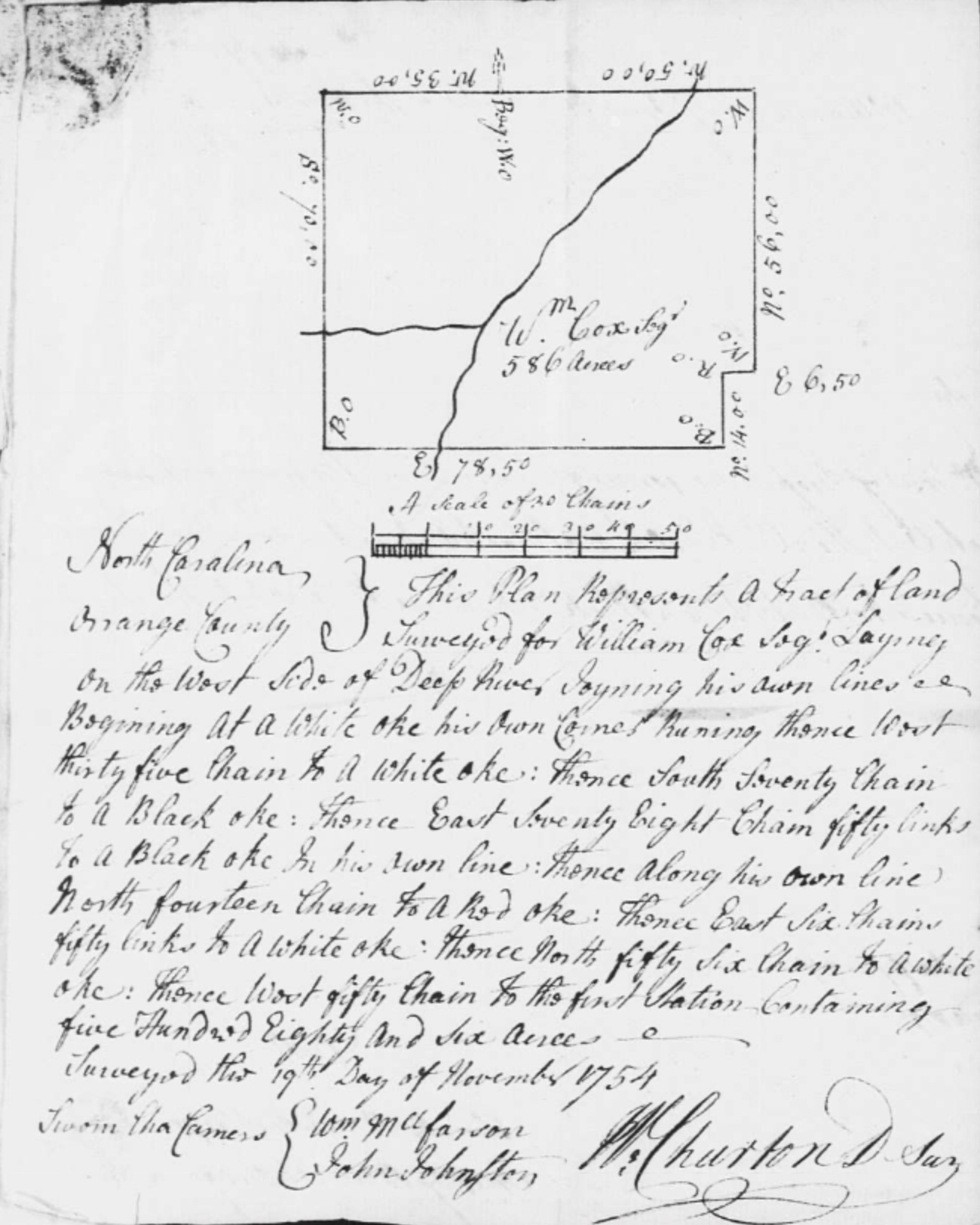
Gv99 Granville to William Cox, 13 May 1755, 586 acres on West side of Deep River, adj his own land, SCC: William McFarson & John Johnston – surveyed on 19 November 1754 by William Churton.
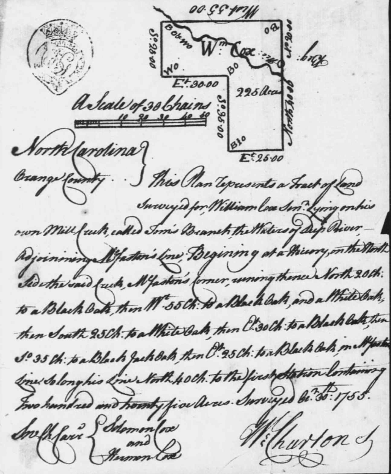
Gv205 Granville to William Cox, 12 May 1757, 225 acres on his own Mill Creek called Toms Branch of Deep River, adj McFarson, SCC: Solomon Cox & Harmon Cox – surveyed on 30 October 1755 by William Churton.
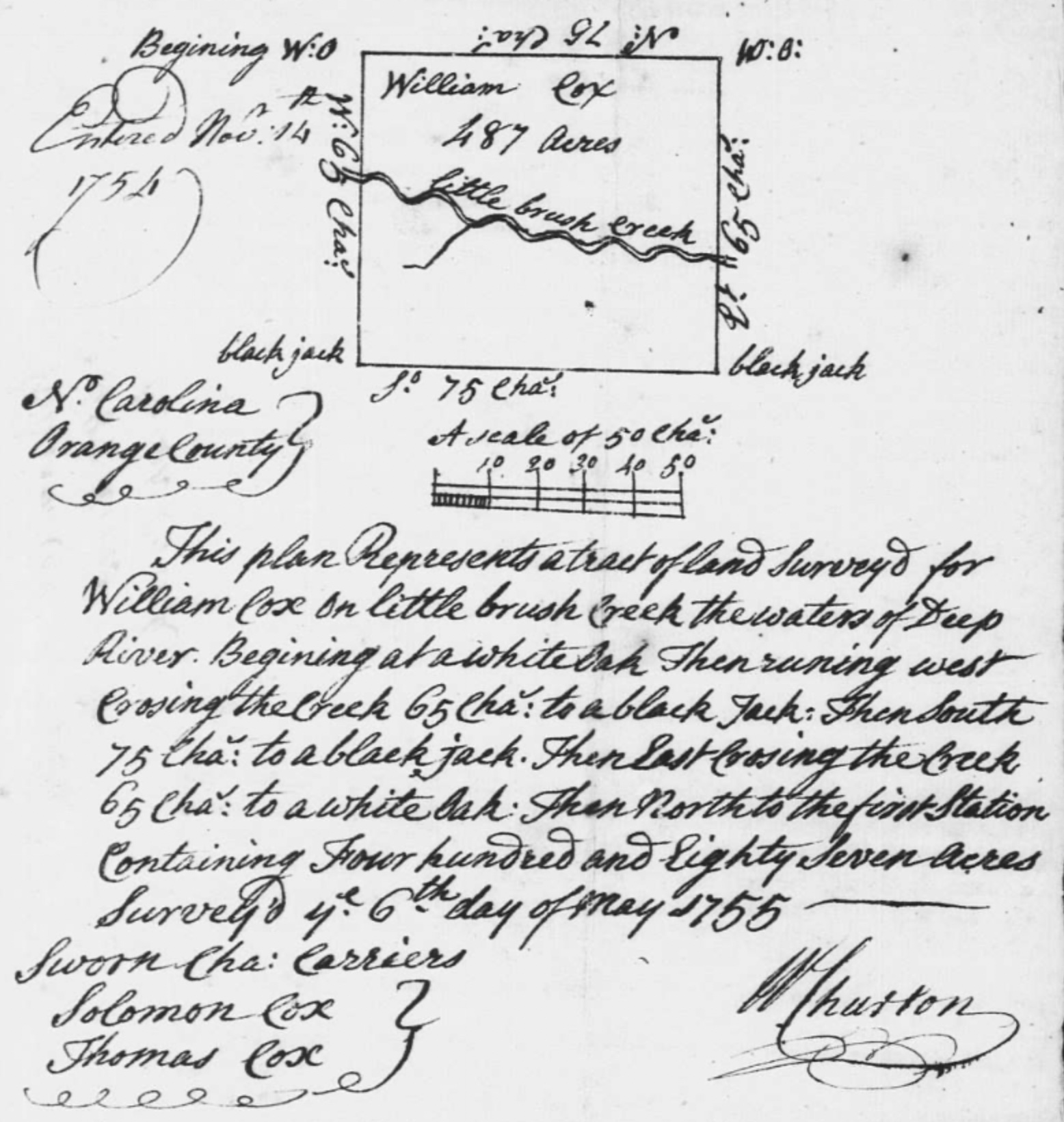
Gv187 Granville to William Cox, 13 November 1756, 487 acres on Little Brush Creek of Deep River, SCC: Solomon Cox & Thomas Cox – surveyed on 6 May 1755 by William Churton.
Gv219 Granville to William Cox, 5 November 1757, 397 acres on both sides of Cox’s Mill Creek of Deep River, adj Harmon Cox, SCC: John Cox & Thomas Cox – surveyed in trust for Samuel Allen on 29 April 1756 by William Churton.

Gv218 Granville to William Cox, 5 November 1757, 375 acres on head of Cox’s Mill Creek of Deep River, on both sides of Crawford’s Road, SCC: Hiliman Hobb & Thomas Allred – surveyed on 30 April 1756 by William Churton.

Gv217 Granville to William Cox, 5 November 1757, 205 acres on both sides of Deep River, adj Peter Youngblood, Harmon Cox, SCC: Thomas Cox & Thomas Cox Jr – surveyed on 4 May 1756 by William Churton.

William secured additional land over the next several years, as did sons Harmon and Thomas.
Gv243 Granville to Harmon Cox, 5 August 1758, 497 acres on East side of Deep River, adj mouth of a gully, SCC: Thomas Cox & Solomon Cox – surveyed on 1 November 1755 by William Churton.

Gv245 Granville to Harmon Cox, 5 August 1758, 665 acres on East side of Deep River, on Narrow Mouth Creek, both sides of Youngbloods Path, SCC: Solomon Cox & Solomon Cox – surveyed on 31 October 1753 by William Churton

Cox, Harmon – Gv381 Granville to Harmon Cox, 1 August 1760, 224 acres on N side of Deep River, adj his own land, SCC: Eleazer Hunt & John Cox – surveyed on 8 October 1759 by William Churton.

Cox, Thomas – Gv244 Granville to Thomas Cox, 5 August 1758, 400 acres on Richland Creek of Deep River, adj Benjamin Cox, SCC: Harmon Cox & Thomas Cox – surveyed on 28 April 1756 by William Churton.

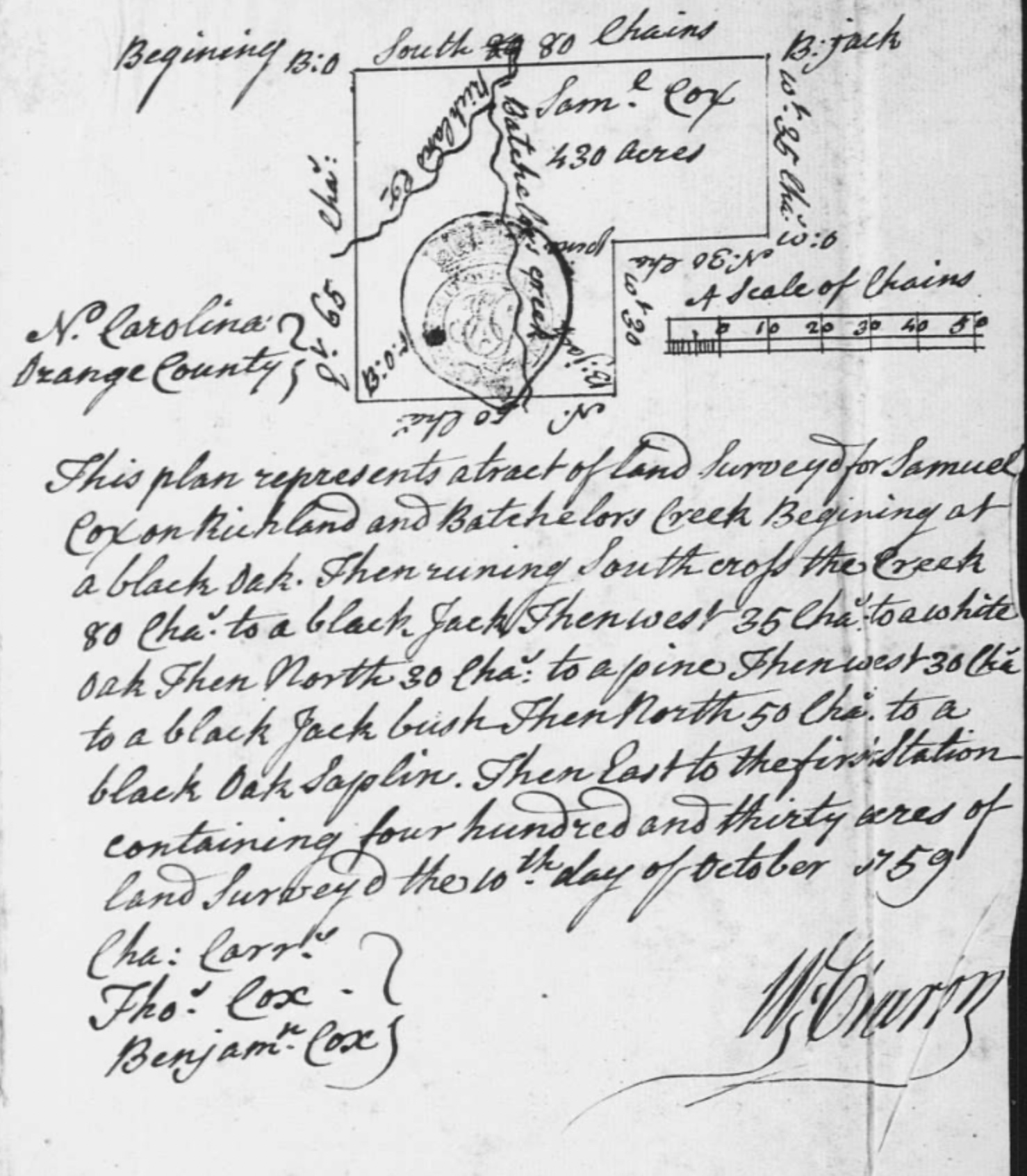
Cox, Samuel – Gv382 Granville to Samuel Cox, 1 August 1760, 430 acres on Richland Creek & Batchelors Creek, SCC: Thomas Cox & Benjamin Cox – surveyed on 10 October 1759 by William Churton.
Sources of Note:

You must be logged in to post a comment.